OSM data to shapefile with specific OSM Tags
Well I had a unique problem or I should say not so unique problem in preparing some OpenStreetMap (OSM) data for import into PostGIS and then export to Shapefiles for my students.
Job at hand:
Generate some shapefiles based on specific OSM data tags more specifically wheelchair access tags.
Tools:
later spatial geeks
Job at hand:
Generate some shapefiles based on specific OSM data tags more specifically wheelchair access tags.
Tools:
- osm2pgsql.exe
- python 3.1 custom script see below
- pgsql2shp.exe this is installed with PostGIS located in the /bin directory
- Postgresql 8.4.4 with PostGIS 1.5.2
- Download and unzip the osm2pgsql.exe for import
- Windows 7 Pro (this is not a prereq, just letting you know what I used)
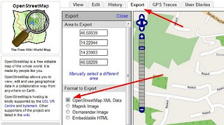
- Download OSM data as .osm for your region using the web tab "Export" on the osm website (see screenshot) or visit GeoFabrik or Cloudmade for shapefiles/OSM data.
- Prepare data for osm2pgsql.exe by
- Edit the import .style file to limit what is actually going into PostGIS so only our needed fields come across. See the wiki page for details
- Edit the .osm file to replace all the Tag names so they conform to support the shapefile limitations. I used a custom PYTHON 3.1 script shown below to do this dirty work.

- field names larger than 10 characters
- field names with ":", ";" " "
Here is the python code that I used to do the data text search and replace of multiple words in preparing the .osm file for import. Just copy the code below and save it as myfilename.py and be sure to change the location of your .osm file and the name of the new output file.
 import sys, os
 def replace_all(text, dic):
   for i, j in dic.items():
     text = text.replace(i, j)
   return text
 # create a dictionary / hash to store the values to replace
 # keys are the current words to replace and values are the new replacement words
 #so the first word is replaced with the second word
 dic = {
 'wheelchair:':'wch_',
 'wheelchair':'wch',
 'surface':'surf',
 'smoothness':'smth',
 'inclination':'incl',
 'capacity:disabled':'cap_dis',
 'footway:left:':'fw_L_',
 'footway:left.':'fw_L_',
 'footway:right:':'fw_R_',
 'footway:right.':'fw_R_',
 'opening_hours':'open_hrs',
 'addr:':'addr_',
 'housenumber':'housnum',
 'guided_tour':'guidtour'
 }
 # Here we open the osm file we want to update and prepare so that the shapefile we produce is happy
 osmfile = open('map.osm', encoding='utf-8')
 filein = osmfile.read()
 # now create the new file that we will use for conversion
 newfile = open('map2.osm', 'w', encoding='utf-8')
 # write the output into the new file
 newfile.write(replace_all(filein, dic))
 #close the 2 open files
 newfile.close()
 osmfile.close()
- Finally import the .osm file into PostGIS using osm2pgsql.exe
- Immediately EXPORT to shapefile with pgsql2shp.exe
later spatial geeks
Comments
Post a Comment