Skip to main content
Search
Search This Blog
Spatial Mounty
Location with Information
Tech Blog
my Business
More…
Posts
June 30, 2015
Geoserver create a new layer using REST API
June 06, 2015
How to fix pyshp error reading shapefile
May 30, 2015
GeoDjango < 1.7 return GeoJSON passing model name in request
May 08, 2015
ogr2ogr Append new Shapefile to existing PostGIS table
February 25, 2015
AutoCAD import x,y,z csv data points
February 10, 2015
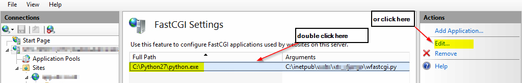
Django GeoDjango deploy on windows server 2012 R2 IIS 8
October 17, 2014
Spatial reference systems and transformations in Austria
September 17, 2014
arcpy write a list of feature datasets from a geodatabase to a csv file
July 03, 2014
Geoserver SLD variable substitution based on attribute
May 20, 2014
Install pgRouting extension with postgresql 9.3
May 12, 2014
ogr2ogr upload shapefile to postgis
Newer Posts
Older Posts
Home